For the ones interested in human interaction with coastal and marine spaces and oceanography in general, San Diego (California, USA) is one of the most interesting and iconic places on earth. San Diego has a diverse and thriving marine life due to the rich waters of the California Current; an outstanding coastal geology shaped by tectonics and coastal erosion; and settings that create a varied range of landscapes and habitats (not to mention the perfect sunsets). If the natural settings alone were not already extraordinary, the proximity with Mexico, the vast military facilities, and the southern California lifestyle make San Diego a unique location. In addition to all that, San Diego is home of the Scripps Institution of Oceanography, one of the oldest, largest, and most important research centres in the world for ocean, earth and atmospheric science.
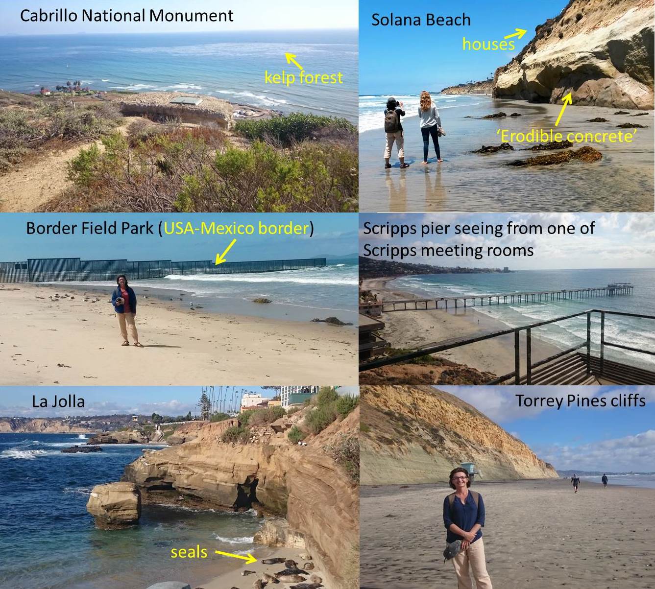
In May 2015, I went to San Diego to attend Coastal Sediments, one of the most important international conferences with focus on coastal research (there were over 350 attendees from the private, public and research sectors). The presentations of my two papers were very well-attended and created very good opportunities for networking. For example, after my presentation on the first day, Julia Chunn-Heer (San Diego County Policy Manager at Surfrider Foundation) contacted me to say she found the presentation very relevant to their work, in particular to current coastal development pressures they face in San Diego. As I was staying in San Diego after the conference to visit local organisations and collate material for teaching and research, I was able to meet Julia again and find out more about one of their projects. She showed me locations in Solana Beach where local property owners are filling wave-cut notches at the cliff base with ‘erodible concrete’ as an attempt to slow down the cliff retreat. Surfrider’s concerns are the preservation of the natural cliff line and therefore to ensure that the concrete used is actually eroding at rates similar to the natural cliff.
After the conference, I visited colleagues of the San Diego State University, Geography Department, and many interesting coastal locations in southern California, including: the Border Field State Park at the border with Mexico, the Tijuana River National Estuarine Research Reserve, Coronado Beach, Cabrillo National Monument, Torrey Pines State Natural Reserve and many other interesting coastal settings between the Mexican border and Oceanside Beach.
I also had the opportunity to visit Scripps installations, including the famous pier, with Ron Flick. At the Scripps pier measurements of water parameters, waves and weather have been collected since 1975. These data and other coastal environment data collected elsewhere are made available online through the Coastal Data Information Program. Ron is currently interested about how high water levels are used as a public land boundary at the coast, and the implications concerning private property legislation (e.g. the implementing private coastal defence structures). One important aspect we discussed, which may result in a future collaborative publication, concerns changes in the position and elevation of the high water line due to major storm impacts or sea-level rise and how/how often public land boundaries may need to be updated. So watch this space for updates!
Conference attendance and the extended stay in San Diego were facilitated by a Fusion funds (SMN) and my R-budget.


 Poverty in the UK: book launch today at BU
 BU contributions to successful Global Health conference
 New paramedic science paper by BU’s Dr. Ursula Rolfe
 Congratulation on newly published systematic review
 Horizon Europe Cluster 3 (Civil Security for Society) 2026 Calls Now Open
 MSCA Doctoral Networks 2026 Call Information Webinar
 Reminder: Register for the ESRC Festival of Social Science 2026 Information Session
 ECR Funding Open Call: Research Culture & Community Grant – Apply now
 ERC Advanced Grant 2025 Webinar
 Update on UKRO services
 European research project exploring use of ‘virtual twins’ to better manage metabolic associated fatty liver disease