Update on progress of our LEAP: Landscape Ecology and Primatology research group at Bournemouth University.
EU-funded postdoc Cici Alexander completed her 2 year position (https://go-leap.wixsite.com/home/forest-3d-ecocarb) with Ross Hill and Amanda Korstjens in September 2017. It was sad to see her go but it’s fantastic to see her four papers all accepted and online now. Cici analysed LiDAR and UAV imaging data to identify trees and forest structural characteristics for the tropical forests that LEAP works at in Indonesia. Our papers are online and open access (although 1 only via BU’s BRIAN):
The work continues in collaboration with our charity partners (Matt Nowak, Graham Usher, Dr. Gabriella Fredriksson) at Sumatran Orangutan Conservation Programme, and Prof Serge Wich from Liverpool John Moores University as well as Dr Abdullah from our international partner Universitas Syiah Kuala. Authors of the completed papers also include Emma Hankinson and MRes student Nathan Harrison.
- Alexander, C., Korstjens, A.H., Usher, G., Nowak, M., Fredriksson, G. and Hill, R.A., 2018. LiDAR patch metrics for object-based clustering of forest types in a tropical rainforest. International Journal of Applied Earth Observation and Geoinformation, 73, 253-261. PDF open access on the journal’s website
In this most recent paper, we identify habitat types using LiDAR data from Batang Toru, Sumatra, Indonesia where the newly identified and highly threatened Tapanuli orangutans occur and a planned dam is threatening the ecosystem.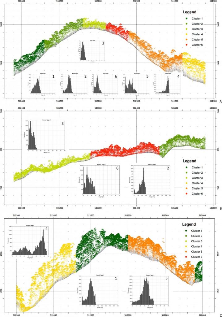
Fig. 6. Vertical profiles through the point cloud from an area of 500 m × 20 m with all the six clusters (A), with the three shortest clusters (B) and the three tallest clusters (C), with points extracted from the Digital Terrain Model (black); Sample height profiles based on ALS point cloud (40 m × 20 m) are also shown.
2. Alexander, C., Korstjens, A.H., Hankinson, E., Usher, G., Harrison, N., Nowak, M., Abdullah, A., Wich, S.A. and Hill, R.A., 2018. Locating emergent trees in a tropical rainforest using data from an Unmanned Aerial Vehicle (UAV). International Journal of Applied Earth Observation and Geoinformation, 72, 86-90. PDF open access on the journal’s website
3. Alexander, C., Korstjens, A.H. and Hill, R., 2017. Influence of micro-topography and crown characteristics on tree height estimations in tropical forests based on LiDAR canopy height models. International Journal of Applied Earth Observation and Geoinformation, 65, 105-113. PDF open access on the journal’s website
4. Alexander, C., Korstjens, A.H. and Hill, R., 2016. Structural attributes of individual trees for identifying homogeneous patches in a tropical rainforest. International Journal of Applied Earth Observation and Geoinformation, 55, 68-72. Pre-print version available in BU repository (or upon request by email).
For more information on the ‘LEAP: Landscape Ecology and Primatology‘ research group, visit our website or like our facebook page. Our work featured also in the BU2012-2018 review (p17).
 Conserving wildlife and tropical habitats in Indonesia
 Getting involved in conservation in Indonesia: an undergraduate perspective


 Poverty in the UK: book launch today at BU
 BU contributions to successful Global Health conference
 New paramedic science paper by BU’s Dr. Ursula Rolfe
 Horizon Europe Cluster 3 (Civil Security for Society) 2026 Calls Now Open
 MSCA Doctoral Networks 2026 Call Information Webinar
 Reminder: Register for the ESRC Festival of Social Science 2026 Information Session
 ECR Funding Open Call: Research Culture & Community Grant – Apply now
 ERC Advanced Grant 2025 Webinar
 Update on UKRO services
 European research project exploring use of ‘virtual twins’ to better manage metabolic associated fatty liver disease