Tagged / IMSET

Conversation article: Documenting the world’s largest prehistoric rock art in South America – new study

Dr Philip Riris co-authors this article for The Conversation about his experiences documenting monumental rock art along the Orinoco River…

Documenting the world’s largest prehistoric rock art in South America – new study
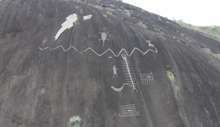
Enhanced image of monumental rock art on Cerro Pintado, Venezuela.
Philip Riris, Author provided

Philip Riris, Bournemouth University; José R. Oliver, UCL, and Natalia Lozada Mendieta, Universidad de los Andes

We weren’t the first to lay eyes on the engraving since it was carved into the hillside any number of centuries or millennia ago, not by a long shot. The Venezuelan archaeologist José Maria Cruxent even recorded it in his diaries in the 1940s – and there were certainly visitors before him.

The site of Cerro Pintado (Painted Hill), in the Venezuelan state of Amazonas, is a local landmark and a well-known fixture on the itinerary of those travelling on the Middle Orinoco River.

Yet viewing the gigantic snake, carved high up on the hillside, immediately ignited both our sense of wonder and our scientific curiosity. Why a snake? Why did its creators climb a towering granite hill to place it there, just so? What about all the other engravings orbiting it – what do they mean?

All these questions and more swirled around our little group as we stood, sticky and mosquito-bitten, in the savanna at the foot of the hill. Its singular status made it all the more intriguing.

While there are other examples of giant prehistoric rock art in other parts of the world, these appear to be the largest. While, as mentioned, some were already known to archaeologists, our team documented others, including over the border in Colombia.

The results reveal a high concentration of these monumental engravings in the region. The subjects of these symbolic works include snakes, humans and centipedes. The animals probably played an important role in the mythologies of the people who made them. The results have been published in the journal Antiquity.

New sites to survey

On our visit to Cerro Pintado in 2015, we supposed that the enormous 42-metre-long snake engraving (probably representing a boa or anaconda, native to the region) stood in splendid isolation. Prior scholars observed that many rock shelters in the surrounding savanna hosted prehistoric paintings, and we had already seen plenty of engravings near our dig sites.

Although often numerous or quite large, none of these sites shared the truly monumental scale of the Cerro Pintado engravings. Its apparent uniqueness led us to dutifully return with a drone to secure better images of the highly inaccessible panel. Already during the first stint in the field, however, we suspected that there was more to be uncovered about the rock art of the region.

Our guide, Juan Carlos García, a local educator and photographer, was well travelled around the area, and had plenty of insights to share. While surveying the islands that separate the calm middle course of the Orinoco River from its turbulent upper reaches, he pointed to the Colombian bank and forthrightly informed us: “Do you see that hill? Over there, behind it, is another snake, as big as Pintado.”

The possibility of another snake was beyond tantalising to us. Did it also have a set of accompanying motifs? Was it truly as big and as visible from far away? For lack of scientific permits in Colombia, or the time to search for a new site even if we had permits, these questions were left unanswered. After four campaigns in Venezuela, our fieldwork funding ended in 2017 and Cerro Pintado remained, as far as archaeology was concerned, a one-and-only location.

Luckily, the project’s principal investigator, José Oliver, at the UCL Institute of Archaeology, secured the means to return to survey the Colombian side in 2018. The results of careful systematic surveys were shared between the team in a flurry of excited text messages and emails, confirming that there was not just one more snake, but several. They were also comparable in size to Pintado and clearly related, yet each with their own twist.

The project’s doctoral candidate, Natalia Lozada Mendieta, from the Universidad de Los Andes, Colombia, now an assistant professor, also returned in 2021 and 2022 to find more snakes. Finally, the entire original team reunited in the field in 2023. Collectively, and with help from local guides, we amassed a database of 13 vast rock art sites with upwards of 150 individual engravings between them.

Striking motifs

To us, the snakes were the most striking motifs, although giant centipedes, humans dancing or playing instruments, and mysterious geometric shapes of unknown intent did not fail to impress. Although not unique, as previously thought, Cerro Pintado is now accompanied by a constellation of related sites – a genuine monumental rock art tradition.

Very large prehistoric petroglyphs, the scientific term for rock engravings, are not unknown. Whales and elk are depicted in the Stone Age art of Norway, and virtually life-size giraffes and camels are known from Niger and Saudi Arabia, respectively.

Highly visible or salient rock art such as this is often presumed to communicate ideas or concepts of importance. While their exact meaning is lost, their impact can be felt through their physicality, meaning their size and placement.

In our cases, we are fortunate to note repeating themes across the indigenous cosmologies of northern South America that allude to gigantic snakes as the creators and protectors of rivers – including the great “river” in the sky, the Milky Way. Yet they are also menacing, predatory and lethal.

This information enriches our understanding of the archaeological record. The snakes were intended to be seen from some distance, reflecting a shared understanding of the world and its inhabitants. What marks the Middle Orinoco out as a unique hotspot, we argue, is the sheer concentration of these enormous works of pre-Columbian art.

They appear to be the largest in the world, and speak to a contested, yet openly communicative cultural landscape during the pre-Columbian period that we are only just beginning to understand.

More importantly, as regional tourism expands year on year, the sites are
increasingly in need of protection, an activity in which indigenous people should have a leading voice. Undoubtedly, there are dozens more sites in this unique monumental tradition to encounter, record and, hopefully, preserve.The Conversation

Philip Riris, Lecturer in Archaeological & Palaeoenvironmental Modelling, Bournemouth University; José R. Oliver, Reader in Latin American Archaeology, Institute of Archaeology, UCL, and Natalia Lozada Mendieta, Assistant Professor, Department of Art History, Universidad de los Andes

This article is republished from The Conversation under a Creative Commons license. Read the original article.
Researchers discover huge Neolithic monument on the Isle of Arran

Bournemouth University researcher involved in groundbreaking discovery on Scottish island.


by Stephen Bates

A team of researchers have discovered what is believed to be a complete Neolithic cursus set within a rich prehistoric landscape on the Isle of Arran, Scotland.

This monument type is amongst the first that was built by farmers in Neolithic Britain and is huge – measuring 1.1km long and 50 metres wide.

A cursus is a vast Neolithic monument comprised of one or more rectangular enclosures. The cursus on Arran is defined by a large stone, earth and turf bank running around the entire perimeter of the enclosure. Constructing this monument would have involved staggering amounts of labour, transforming the entire local landscape.

This monument type could date to perhaps as early as 3500 BC, researchers say. It is the most complete example of this site type found in Britain and the opportunity to investigate a cursus bank is very rare and hugely exciting.

Prehistoric field boundaries, clearance cairns and round houses, at least some of which may be contemporary with the monument, have also found in the same landscape, all preserved within peatland, sealing the archaeological layers. Ancient soils representing the original Neolithic land surface, together with cultivated soils from the Bronze Age period, provide an unparalleled opportunity to understand how contemporary farming practice and settlement interacted with the cursus monument and how early farmers transformed this place.

Dr Emma Jenkins, Associate Professor in Archaeology at Bournemouth University, co-led the landscape geoarchaeology and environmental science work at the site, supported by Dr Sarah Elliott, Deputy Head of Department, Life and Environmental Sciences (LES) and Harry Manley, Demonstrator in LES.

This involved excavating areas near the cursus into the Neolithic land surfaces and Bronze Age field systems which will allow samples to be taken for dating and other environmental evidence. This will help the team to understand how people used and managed this important landscape and feed critical information into the rewilding strategy about the landscape history of the area.

Dr Jenkins said, “The Isle of Arran is well known for Machrie Moor with its Prehistoric stone and timber circles; standing stones and burial cairns but the discovery that these may be part of a much larger complex which included this enormous cursus elevates this into a region of global significance on a par with other ceremonial landscapes like Stonehenge. As an environmental archaeologist I am particularly excited by the discovery of well-preserved soils, contemporary with the creation of the cursus which means we can investigate how people used and modified this landscape from the time of the first farming communities in Britain.”

This research will provide invaluable information about landscape history and past ecosystems that will feed into the Rewilding strategy currently being put together by landowner David Bennett and the Northwoods Rewilding Network and wider work by Arran Geopark.  The team also supported participation by members of the local community in the research process and are exploring future learning and creative opportunities responding to the investigations.  Artists from the region were supported by North Ayrshire Council and Arran Theatre and Arts Trust to explore the excavation.

Professor Nicki Whitehouse, Professor of Archaeological Science, University of Glasgow,  said: “The initial discoveries reveal a highly unusual combination of a ceremonial monument within a prehistoric farming landscape. It is part of a continuum that likely linked to the ritual site at Machrie Moor, probably forming part of something much more extensive. The science work will allow us to understand about the animals and plants people farmed, how people impacted the landscape and its ecosystems and transformed their soils for cultivation – and what we may learn from this today.”

The combination of investigating all these elements together is highly unusual and has also involved experts from Universities of Birkbeck, Reading, Coventry, Birmingham, and Southampton as well as archaeologists from Archaeology Scotland and Historic Environment Scotland.


The discovery has seen widespread media coverage, including in The National, The Guardian, The Times (paywall) and The Scotsman (paywall).

Earth Day 2023: How BU research is helping to protect and preserve a sustainable environment

Today is Earth Day, an annual event dedicated to raising awareness and inspiring action to tackle the various environmental challenges facing our planet. The day is marked by an estimated one billion people across more than 190 countries.

This year’s theme is Invest in our Planet, marking the importance of dedicating time, resources, and energy to protecting our environment and solving the climate crisis.

At BU, we’re passionate about protecting and preserving a sustainable environment. Through our research we’re helping to save endangered species, protect coastal and freshwater regions, and understand ecosystems – learning from the past to impact the future. Here are just some of the ways in which we’re doing so:

3DPARE project – creating new habitats for marine life

Coastal habitats have been gradually degraded through a range of human activity, including fishing, dredging, pollution and coastal development. Along with partners in France, Spain and Portugal, BU is part of the 3DPARE (3D Printing Artificial Reefs in the Atlantic) project – which is exploring whether 3D printed artificial reefs can help provide new habitats for marine life and increase biodiversity.

Nine reefs made from sustainable, low-carbon concrete were placed in Poole Harbour in March 2020 and are now home to over 100 species – including edible crab, pollack, wrasse, gobies and mullet.

ADDISONIC – better prediction and extension of the lives of materials, reducing global waste

The ADDISONIC (Advanced Manufacturing Ultrasonic Fatigue Prediction and Life Extension) research cluster at BU is finding ways to better predict and, most importantly, extend the lives of engineering materials.

The team aims to extend the life of components by applying ultrasonic fatigue testing to much more quickly and reliably predict the lifespan of individual parts.

This will not only enable these parts to be manufactured more efficiently but will also reduce the amount of material used in their production –  decreasing waste and reducing the likelihood of materials ending up in landfill.

Institute for the Modelling of Socio-Environmental Transitions (IMSET) – using the past to support our response to environmental change

With expertise across archaeology, ecology and modelling, IMSET aims to address the issue of how we respond to environmental change, learning from how past societies adapted.

An aerial image of the Brazilian Atlantic ForestCurrent research, being led by Dr Phil Riris, is exploring how human occupation and land use over hundreds of years has affected the Brazilian Atlantic Forest – one of the world’s most critically threatened tropical forests. It’s hoped that these insights will help to inform future protection and conservation efforts.
 

Find out more about BU’s work and research protecting and preserving a sustainable environment

Globe icons created by Freepik – Flaticon

IMSET Seminar: Modelling land use in the ancient Near East

Thursday 22 April at 4pm 

Modelling land use in the ancient Near East: methodological problems and interpretive potential with Dr. Dan Lawrence, Durham University 

Land use and land cover (LULC) changes have important biophysical and biogeochemical effects on climate via a variety of mechanisms. The PAGES working group LandCover6k aims to produce global reconstructions of land use and land cover based on archaeological data to provide climate modellers with datasets for sensitivity testing. The Ancient Near East has a long history of agricultural and pastoral exploitation, and as such represents a key area for the understanding of human induced landcover change. This paper will discuss the methods through which land use has been reconstructed by the Middle East group of the Landcover6K project. It will also show how these methods can also be used by archaeologists to investigate socio-ecological systems through time, building on datasets collected through the ERC funded Climate, Landscape, Settlement and Society (CLaSS) Project. This project aims to collect all archaeological settlement, zooarchaeological and archaeobotanical data available for the Fertile Crescent over the Holocene. Combining land use modelling with archaeologically derived evidence for past population and subsistence practices has significant interpretive potential. We illustrate this by presenting new results on the impact of the 4.2kya event, a period of drought associated by some with the collapse of the Akkadian empire and widespread population decline. We will also discuss preliminary work on long term trends in social complexity, productivity and resilience. 

Find out more and book your place.  


IMSET Seminar: Understanding coastal change

Thursday 18 March at 4pm 

Understanding coastal change: impact and implications global to local scales with Dr Sally Brown, Bournemouth University  

Coastal zones are under multiple threats of natural and anthropogenic change. The impact of these threats are anticipated to worsen with climate change and the effects of sea-level rise. In this presentation, Sally will highlight different elements of her research, including how physical processes and socio-economic change vary throughout time, and demonstrate methods and solutions to adapt to these changes. Examples will be taken from global, regional and local scales from areas that Sally has worked on around the world. 

Sally is a coastal and climate change adaptation scientist. She joined BU in 2018, and as all but six weeks of her time at BU has been part-time or working from home, she is keen to integrate more and work with others in research at BU. Find out more about Sally’s research.  

BU Research Matters: the evolution of research during a global pandemic – joining our research community

Dr Marc Vander Linden - Bournemouth University Staff Profile PagesThis week on the Research Blog, we are exploring how our amazing community of researchers have evolved and adapted their research activities in response to the COVID-19 pandemic. 

Dr Marc Vander Linden, who joined BU in March 2020 as part of the creation of the Institute for the Modelling of Socio-Environmental Transitions starts the mini-series off. Below, Marc shares his reflections, details how he has adapted and explains why we still need face-to-face interaction: 

“A year ago, I joined Bournemouth University as a senior lecturer within the newly created Institute for the Modelling of Socio-Environmental Transitions (IMSET). Obviously, the prospect of a national lockdown was then looming closer and closer but I never thought that, several months later, I would still be a “virtual colleague”, delivering my – new-ish by now – duties from home and through the 13inch window of my laptop screen. We all have experienced first hand the challenges of the current situation. Being married to an academic and parent of two (very resilient, I must proudly add!) children, it goes without saying that home-schooling has taken its toll on working conditions. These have not been ideal to discover and manage the many administrative and teaching tasks incurred by a new job. In this sense, doing research has been indeed a challenge, but overall less a luxury than a necessary intellectual lifeline.

I am an archaeologist working on past population history, and long-term human-environment interactions, especially the mechanisms and consequences of the introduction and development of early farming techniques across Europe. My research covers multiple facets, each having been affected in different ways by COVID-19. The most-well-known, “romantic” thing about being an archaeologist is the field, in my case digging in caves in Montenegro. Obviously, with travel bans and the local hardships of the pandemic, any form of fieldwork has been impossible to undertake. As I was about to start surveying a new region, the lack of fieldwork not only has an immediate effect upon my research, but will also have negative repercussions felt over several years to come as I cannot dig new sites, identify new research problems and apply for corresponding funding. Yet, this unexpected pause also offered opportunities to revisit and complete older work, and prepare it for final publication thanks to a collective effort involving former post-docs, PhD students, and local Serbian and Montenegrin collaborators.

Another part of my research draws on legacy data, which is assembling, compiling and analysing datasets from published and unpublished literature. This includes, among others, collating information scattered in a multitude of individual reports related to changes in past farming regimes (e.g. presence of certain crops and weeds, or the preference for particular animal domesticates, or the contribution of hunting to the economy). The resulting “big data” not only constitute the empirical baseline for a range of analyses, but these results can also be used by collaborators from disciplines that consider estimates of anthropogenic activity (e.g. anthropogenic land cover models). Such multi-layered work is only possible by being part of an extensive international network of researchers, meeting regularly in a virtual world of Zoom meetings, shared folders, google documents, sometimes spiced up by the pleasure of doodle polls to identify the right meeting slot across multiple time zones. In many respects, the COVID-19 induced familiarity of online platforms and tools has bolstered this dimension of my research and made me more open to new collaborations.

This being said, the picture is not entirely rosy and, in so many ways, I’d say the most difficult part has actually been to become a BU colleague. After all, it is difficult to lose sight, when constantly stuck at home in front of a laptop, that you’re part of a new institution, with rules to follow and timelines to respect. As part of IMSET, “older hands” have provided outstanding support to us newbies, and lots of energy has gone into creating and maintaining contact through weekly – virtual obviously – lab meetings. Though we’ve made huge strides to come together as a group, the biggest drawback still remains to not being able to pop in someone’s office for advice or a simple chat. Online collaboration presents numerous advantages when relying upon and interacting with a huge body of collaborators and, arguably, my research has developed well despite, if not thanks, to the “new normal” imposed by COVID-19.

Yet, I’m desperately craving for the inherent simplicity and spontaneity of unplanned interactions with talented colleagues for diverse scientific horizons, those simple moments which, in my experience, are so essential in generating successful, innovative and fun research”.


IMSET Seminar: Exploring the chaîne opératoire of applied long-term human ecodynamics

Thursday 21st January 4pm – 6pm

Exploring the chaîne opératoire of applied long-term human ecodynamics: examples from the human paleocology of Subarctic and Arctic seas.

Book your place in the seminar with Professor Ben Fitzhugh, Department of Anthropology, University of Washington.

Professor Fitzhugh’s research focuses on human-environmental dynamics and archaeological histories of maritime/coastal hunter-gatherers especially in the North Pacific. His research addresses questions of human vulnerability and resilience in remote subarctic environments.

Researchers studying long-term human ecological histories increasingly promote the relevance of this work to contemporary environmental managers, policy makers, and heritage communities. After all, our case studies and comparative insights capture greater ranges of socio-environmental variation and longer temporal sequences than are available to planners tethered to the short observation scales. These longer time-lines and more varied “completed experiments of the past” make it possible to track dynamic relationships and downstream legacies driving more and less sustainable strategies and relationships. This information should help us to avoid the mistakes of the past and to build policy on robust understandings about the capacities of systems for stability and change. Nevertheless, meaningful engagement remains limited. If we are serious about this effort, we owe it to ourselves to examine the practical challenges and paths to solutions to implementation of applied long-term human ecodynamics. For this talk, Professor Fitzhugh will expand on the need for a “chaîne opératoire of applied long-term human ecodynamics.” Chaîne opératoires are the inferred technical steps perceived to govern the production, use and discard of technological objects like stone tools, and his argument here is that we could stand to investigate the impediments and limitations of practice that keep academic work at arms length from management policy. Using climate, marine ecological and archaeological case studies from the subarctic North Pacific, he will explore key steps involved in forming and bringing compelling human ecodynamic scenarios of the past into dialogue with contemporary management science and policy. These steps involve managing data uncertainties, unequal resolutions and relevance, disparate interpretive constructs, and epistemic and ontological asymmetries.

Professor Fitzhugh is currently Director of the Quaternary Research Center at the University of Washington, and in this role, seeks to promote interdisciplinary scholarship in the evolution of the earth surface (and the role of humans in it) over the past two and a half millions years.

https://anthropology.washington.edu/people/ben-fitzhugh

Professor Fitzhugh will speak for approximately 1 hour, followed by Q&A.

Book a place at this seminar via eventbrite.

Virtual Coffee with IMSET

Thank you to those who attended the IMSET launch last week. We hope that you now have a better idea of who we are and what we are aiming to do.

As a follow-up, we will be holding a ‘virtual coffee with IMSET’ on Monday 30th November between 3.00pm and 4.00pm to enable more informal chat and discussion. We do hope you can make it.

Please contact SIA@bournemouth.ac.uk if you’d the meeting details.