Google Under-the-Earth: Seeing Beneath Stonehenge is the first application of its kind to transport users around a virtual prehistoric landscape, exploring the magnificent and internationally important monument, Stonehenge.
The application was developed by Bournemouth University archaeologists, using new field data gathered during their work with colleagues from the universities of Sheffield, Manchester, Bristol, Southampton and London as part of the Stonehenge Riverside Project. Google Under-the-Earth works by adding layers of archaeological information to Google Earth technology.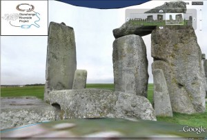
The unique visual experience lets users interact with the past like never before. Highlights include taking a visit to the Neolithic village of Durrington Walls, a trip inside a prehistoric house and the opportunity to see reconstructions of Bluestonehenge at the end of the Stonehenge Avenue and of the great timber monument called the Southern Circle, as they would have looked more than four thousand years ago.
The project is funded by the Arts and Humanities Research Council (AHRC) and Google Research Awards, a program which fosters relationships between Google and the academic world as Google fulfils its mission to ‘organize the world’s information and make it universally accessible and useful.’
But this fabulous educational and cultural tool does not end with Stonehenge. Archaeological scientist Dr Kate Welham, project leader at Bournemouth University, explained that it is the start of something much bigger.
“It is envisaged that Google Under-the-Earth: Seeing Beneath Stonehenge could be the start of a new layer in Google Earth. Many of the world’s great archaeological sites could be added, incorporating details of centuries’ worth of excavations as well as technical data from geophysical and remote sensing surveys in the last 20 years,” she said.
Dr Nick Snashall, National Trust Archaeologist for Stonehenge and Avebury World Heritage Site, said: “The National Trust cares for over 2000 acres of the Stonehenge Landscape. Seeing Beneath Stonehenge offers exciting and innovative ways for people to explore that landscape. It will allow people across the globe, many of whom may never otherwise have the chance to visit the sites, to share in the thrill of the discoveries made by the Stonehenge Riverside team and to appreciate the remarkable achievements of the people who built and used the monuments.”
You can download the application from the Google Under-the-Earth: Seeing Beneath Stonehenge site. The tool is easy to use and requires Google Earth to be installed on your computer.


 BU contributions to successful Global Health conference
 New paramedic science paper by BU’s Dr. Ursula Rolfe
 Congratulation on newly published systematic review
 Equitable Partnerships in Global Health Research
 Horizon Europe Cluster 3 (Civil Security for Society) 2026 Calls Now Open
 MSCA Doctoral Networks 2026 Call Information Webinar
 Reminder: Register for the ESRC Festival of Social Science 2026 Information Session
 ECR Funding Open Call: Research Culture & Community Grant – Apply now
 ERC Advanced Grant 2025 Webinar
 Update on UKRO services
 European research project exploring use of ‘virtual twins’ to better manage metabolic associated fatty liver disease